|
Town: Low &
Burbank
County: Coos
Mountain or Hill: Currier Mountain
Height above sea level: 2790 FT
Tower Structure Height: Unknown
Latitude: 44-19-15
Longitude: 71-24-02
First date of
operation: 1916
Operating Agency: White Mtn Nat. Forest
Type:
Unknown 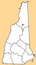
|